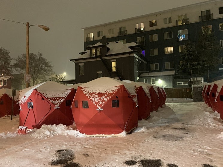
Shelters and Restrooms
Introduction
The purpose of this Atlas is to answer the question, "How has COVID-19 impacted the spatial patterns of the Denver unhoused population in relation to public resources in the city core?"
COVID-19 signified a crisis within a crisis for unhoused communities. Exploring the changing shelter situation, closures of public restrooms, and the ongoing sweeps in Denver illustrate the complex obstacles that unhoused individuals continue to experience.
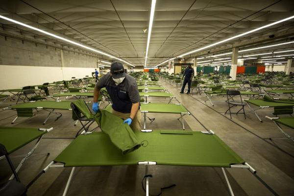
Shelter Capacity and Closure
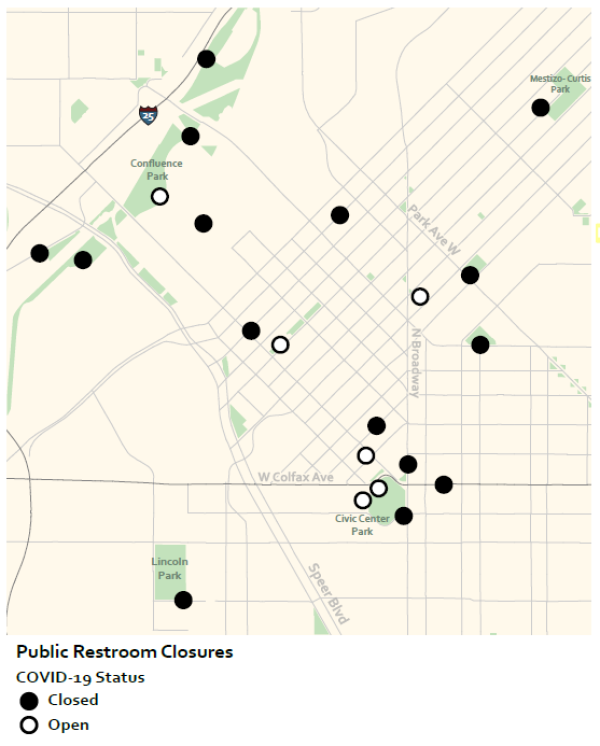
A global pandemic that necessitated self-isolation made congregate living situations like homeless shelters extremely dangerous. Shelter data comes from the Metro Denver Homeless Initiative, the City and County of Denver, and the shelters themselves. Each shelter was put into three categories: temporarily closed, opened during COVID-19, or reduced capacity. Two facilities closed temporarily, three shelters reduced capacity by 50% or less, and four shelters reduced capacity by over 50%.
While the City worked to create expanded shelter space (shown above), many unhoused individuals still felt unsafe using shelters and felt they could better physically distance living in outdoor encampments. Overall, COVID-19 left unhoused individuals who relied upon indoor shelters with few options.
Public Restrooms
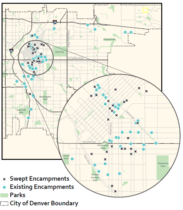
Public restroom closures illustrate COVID-19's severe impact on resource accessibility. Restroom data comes from Denver Open Data and the Denver Department of Public Health (DDPHE). Additionally, data was sourced from the group From Allies to Abolitionists, where a community member checked the closures of all restrooms in person. Of the permanent restrooms explored on page 5, only seven were open during 2020. Without restroom access, conditions in encampments declined. Rather than providing new public restroom resources, the City used deteriorating conditions to justify additional sweeps. Overall, the closure of public restrooms in the COVID-19 pandemic added more obstacles for unhoused individuals.
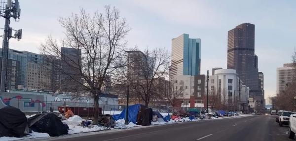
Encampments and Sweeps
Encampments
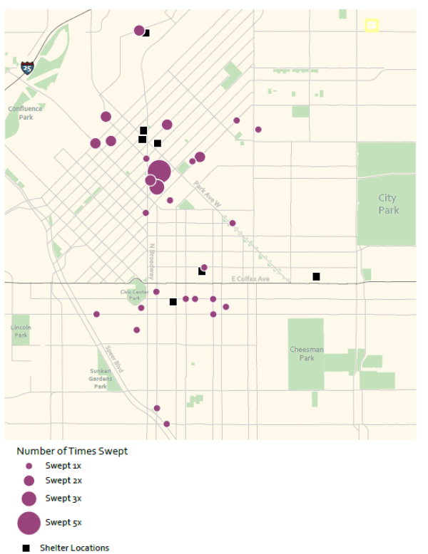
As shelters became hazardous, individuals turned to outdoor encampments in search of safer conditions. A spatial analysis of encampments illustrates the locational strategies of unhoused individuals in response to COVID-19. Encampment data comes from an informal map utilized by Denver Homeless Out Loud (DHOL). Existing encampments were labeled as circles, while swept encampments were labeled as "x" marks for comparison. Sweeps took place within a few miles of the city core, mostly around Civic Center and Five Points neighborhoods. However, encampments that evaded sweeps stretch far south and east along major highways.
Sweeps force individuals into a state of constant movement and push many outside of the city core. Within the context of COVID-19, this pattern is even more dangerous. According to the CDC, constant movement causes individuals to lose connections with resources and contributes to the spread of COVID-19.
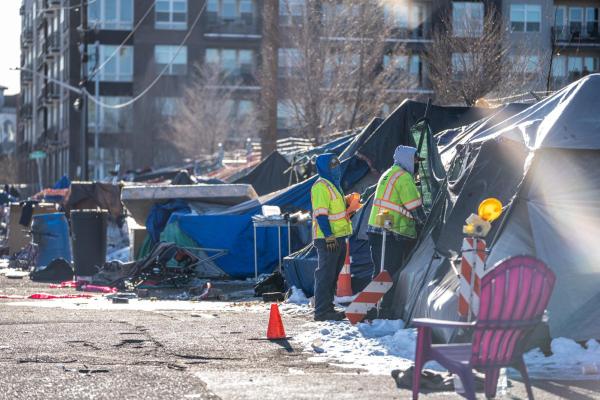
Sweeps
A spatial analysis of the sweeps, or the displacement of unhoused encampments, highlights areas where unhoused individuals are excluded. Sweeps data comes from Denver Homeless Out Loud (DHOL), Once plotted, sweeps were symbolized using the “Number of Times Swept”. Over the year, the city displaced nearly 40 encampments, often sweeping locations more than once as individuals returned to the same spaces to set up camp. This finding emphasizes the ineffectiveness of the sweeps. Individuals do not disappear after a sweep; they set up encampments elsewhere or return to the same spaces.
These findings reveal the extent of marginalization that unhoused individuals experience. The City displaced people during a public health crisis and pushed them to the margins. Prioritizing affordable housing is one step toward ending the unhoused crisis and ensuring improved outcomes in the face of future health hazards.
Denver, Colorado: 2020
Emergency Homeless Shelter COVID-19 Status
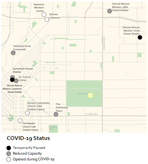
Republished from Briggs (2022)
Denver, Colorado: 2020
COVID-19 Public Restroom Closures
Republished from Briggs (2022)
Denver, Colorado: 2020
Swept Encampments vs. Existing Encampments
Republished from Briggs (2022)
Denver, Colorado:
Number of Times a Single Area was "Swept" in 2020
Republished from Briggs (2022)
A subsequent analysis available in Briggs (2022).
Lucy Briggs received her Bachelor of Arts in Geography (Urban Studies and Planning) in 2021. She recently committed to a pursuing an MA in Urban and Regional Planning at UCLA.
[expand title="References" style="regular"]
- Briggs, L. (2022). Left Behind in Lockdown: COVID-19 and the Denver Unhoused Community . The Geographic Bulletin.
- CDC. (2020). Interim Guidance on Unsheltered Homelessness and Coronavirus Disease 2019 (COVID-19) for Homeless Service Providers and Local= Officials. https://www.cdc.gov/coronavirus/2019-ncov/community/homeless-shelters/unsheltered-homelessness.html (retrieved December 21, 2020).= -
- Colorado Department of Transportation. (2020). CDOT-OTIS Online Transportation Information System. Data Catalog. https:dtdapps.coloradodot.info/otis/catalog.
- *Denver Homeless Out Loud (2020). [Map of Encampments created by Denver Homeless Out Loud]. Retrieved from https:// www.google.commasdu/0viewermid=1yhaWBLU8AU9PWCs2zq8q2QsrAR8IDB3u&hl=en&fbclid=IwAR2apMde7TO4957Ht52t0zR_hAC3dde9rWLe RIEYycJ74l_jVSwl0uCh97= w&ll=39.71803871522253%2C-104.92579115000001&z=12
- Denver Homeless Out Loud (2020). DHOL Sweeps Tracker [Data Set]. Retrieved from https://docs.google.com/spreadsheets/d/1-- V_Sqcnd5sSU6-1oY4-b9Ut6OiaKN5RoMDuJbFHw08/edit#gid=0
- Denver Parks and Recreation. (2020). Denver Open Data Catalog: Park Restrooms. https://www.denvergov.org/opendata/dataset/city-and-county-of- denver-park-restrooms.
- Denver Parks and Recreation. (2020). Denver Open Data Catalog: Parks. https://www.denvergov.org/opendata/dataset/city-and-county-of-denver- parks.
- Denver Public Health and Environment. (6 March 2020). Restroom and Hand Washing Facilities - Denver, CO. Retrieved from https://d3n8a8pro7vhmx.cloudfront.net/mdhi/pages/1374/attachments/original/1584042835/Restrooms_11MAR20_withRestaurant.pdf?1584042835= -
- From Allies to Abolitionists (2020). Message to the Mayor 2020 Report (Rep.). Denver, CO: From Allies to Abolitionists. file:///C:/Users/lucyb/Downloads/%23messagetothemayor%20summary%20report-FINAL%20FOR%20WEB.pdf
- *Hecker, M. E. (2020). Denver Sweeps City's Largest Homeless Encampment. Westword. https://www.westword.com/slideshow/photos-denver- sweeps-police-protest-largest-homeless-encampment-11853381.
- Semon, E. (2020). Large Homeless Encampment Near Civic Center Park Will Soon Be Dismantled. Westword. https://www.westword.com/slideshow/denver-closes-liberty-park-due-to-rat-infestation-11604834.
- *McCormick-Cavanagh, C. (2021, February 17). Before Move-In Day, I Spent the Night at Denver's Second Safe-Camping Site. Westword. https://www.westword.com/news/denver-safe-camping-site-homeless-encampment-sweep-church-11862833.
- Mitchell, D. (1995). The end of public space? People's Park, definitions of the public, and democracy. Annals of the Association of American= Geographers, 85(1), 108-133. https://doi.org/10.1111/j.1467-8306.1995.tb01797.x
- *Staff, W. (n.d.). Inside the National Western Complex Homeless Shelter. Westword. https://www.westword.com/slideshow/photos-denver- opening-600-man-homeless-shelter-at-national-western-complex-11684720.
*Photo Credits